From Dr. Strangelove to Canada and beyond, the journey's and memories of my life with G.

Monday, November 27, 2017

Postmortem...


Great Sand Dunes Nation Park & Preserve - Southern Colorado
It has been a long time since writing here and a quick update is in order.

This year was a real disappointment for us.  We went to Chama with high hope of a really good season.  I had prepared trip mileage guides and had an abundant amount of pins on hand to to give our riders a pleasant and meaningful ride.  All came to naught as my assigned trips spread from once weekly to over 10 days in one instance.  Nearing the last of our time there we decided to leave early for home.  The pins will be distributed to family and friends and the mileage guides went to file 13. 

I was approached regarding the possibility of scheduling docents but in the end declined feeling they needed a younger person to do that job and I didn't need the stress.  We attempted the purchase of a small real-estate lot in Chama but that fell through.  In the postmortem G and I found it difficult to justify the time and expense associated with traveling to Chama for the paucity of time actually spent doing what we had planned for.

During this trip we did enjoy traveling to Silverton and several other places in Southern Colorado thus, we have re-oriented our travel plans accordingly.  Next year we will make several short trips west instead of a single long stay.  We will also be staying at a RV park near Antonito, Colorado instead of Chama.  Our time will be spent exploring places G and I have discussed for many years.  While focusing on Colorado we also hope to finally see the upper Hudson River Valley and Vermont next year.  As for the Cumbres and Toltec, well, if the opportunity to docent on a trip arises I will certainly take it however, based on this year that seems a remote possibility.

The research work for the Cumbres and Toltec is finished and now on the shelf gathering dust.  All in all it was fun for one year and not so much the next, time to move on.  I have cleaned work space in my little "office" to pick-up incomplete projects shelved back in 2015 which remained to this day buried under piles of research until revealed, exactly where I stopped.

I will continue to cover our travel's and my irrational rants on occasion but the site will look a bit different as you will notice.  

Tuesday, February 14, 2017

Things we accumulate...

Bridge on the Allegheny River - Clarion County, PA
With G gone for the next few weeks I have already fallen into a familiar evening routine acquired from her previous visits with her sister in Nevada.  A light meal paying bills a TV if anything seems interesting then study, or reading, followed by exercise and sleep.   It tends to develop introspection with often unexpected recollections.

Yesterday I wrote a Facebook post about a favorite old movie "Mystery Men" in it I mentioned the Mystery Men's sleek daily driver a well worn 1959 Rambler Rebel Station Wagon.  This humble vehicle reminded me of the long gone Studebaker's my Mother's family regularly drove.  I particularly remember several of them, Uncle Paul's 1953 Studebaker Starlight Coupe, Uncle Don's Model A touring car and Aunt Betty's 1950 Studebaker Champion Starlight Coupe.

Uncle Paul's cars were always perfectly maintained.  Neat, clean, not a scratch to be seen and in this piece of rolling perfection he would take us on a ride through the forests in the hills above the Allegheny River telling stories and scaring us with tales of the ferocious "Indians" hiding behind the trees.  It was all terribly frightening for youngsters and we would scream and laugh afterward.  And for Paul seeing the children have fun was far more important than his perfect automobile.

Uncle Don's Model A was a faded green with no top or windshield and torn upholstery.  The starter didn't work and he had to crank it to get the ruin running.  As with Paul the favorite activity was driving through the forest no, tearing through the forest, with the car full of siblings and cousins all jumping up and down in the back seat while Don drove like a mad man.  We would get back to the house in West Monterey exhausted and laughing.

Aunt Betty had the 1950 Studebaker.  It was a funky green coupe with a bullet nose and turret top.  Betty also drove like a nut through the countryside and her favorite habit was racing the trains from Parker to the family home in West Monterey.  The distance was around 5 miles at river level but 8 by road.  You could hear the whistles from the trains echoing up the Allegheny River in Parker when the trains were below West Monterey.   The back seat of her coupe was filled with happy screaming children as we knew what was coming on the final speedy plunge down Doc Walker Road into West Monterey.

The road wound through the forest bursting into the sun in the final quarter mile to the railroad crossing at Smith's General Store.  Imagine, if you will, the rush to the crossing only to see this...
speeding directly toward you a scant 100 yards away.  Was it imprudent?  Well, yes in our time but, in those carefree years we weren't in the shadows of later years.

The last memory of a speedy drive was a ride with my Mother in her Toyota Corolla - similar to the one in this picture.  Mother's cars were always a mess festooned with dents and filled with cigarette butts and trash.  She drove the 15 miles to the family home as the sun was setting.  Careening through the forest, cigarette in hand, she cackled while fumbling for the light switch, which she didn't find - it was terrifying.  But, this isn't my memory it is that of my children. 

My Mother met us in Emlenton when our family was returning home to Alton, IL from a visit in Connecticut.  Mother's home being on the way, G and I left the children with her for a short visit while we drove on home.  A few days later we drove back to Pennsylvania to bring our children home and that is when we heard the story of a mad drive in the dark.  This is the last memory of Mother, a few short years later she died.

It's funny how objects bring back such powerful memories.  For me a this picture of a quirky Gremlin is a reminder of the joy and completeness of family - We brought home our first two children in a car very much like this.

Tonight I will continue my studies and perhaps find a good movie to watch along the way.  In the weeks that G is away I will again find items that spark memories - the things we accumulate along the way which fade as our visit to this place comes to an end.  

Thursday, January 26, 2017

Winter on Cumbres Pass....


In response to a Facebook post regarding the situation on Cumbres Pass at this time of year, January 2017, a few pictures were passed back and forth.  A proper response has to deal with the "Devil" of the San Juan Extension, the snow problem.  I have written about the snow removal equipment previously and the difficulty of operating a "snow train."  Keep in mind the snow issue was a driving factor in operations of the extension over the portion from Antonito to Chama.  In all the effort ranged over 45 miles of the district and the worst of the problems wasn't at Cumbres it was at Windy Point just below the Pass to the west and at the most difficult through the Los Pinos Section below the Pass to the east.  By its nature the snow problem is a significant element of the interpretation during the six hours of the 64 mile journey on the Cumbres and Toltec.  - 44 of 64 miles -


Let's begin with a picture taken this morning from a highway camera of the Colorado Department of Transportation at Cumbres Pass.   This picture was taken after a storm deposited over 18" of snow through a 12 hour period.
Cumbres Pass 01-25-2017
The Cumbres Section House is just outside the frame of reference to the left in this picture.  Compare this picture to the following historic picture:
Cumbres Pass - unknown date prior to 1965
The snow in this picture is well in excess of 6' in depth and has been clearly cut.  Note the man standing on top of the impacted snow and the level of the snow at the Section House.
Steam Powered Rotary Snow Plow stalled in drifting snow
 Snow depths through the drifts range up to 20' in places.
 The railroad built 13,000' of snow sheds between Coxo Curve below Cumbres (MP 332.20) and Cascade Trestle (MP 319.95) to combat the snow problem.  The snow sheds proved ineffective and by the 1920's all had been remove intentionally or by fire.  The introduction of higher powered locomotives changed the game and the railroad resorted to the power of steam driven rotary snow plows and other equipment such as pilot snow plows, still seen mounted on various K36's, or flangers.
C&TS Steam Powered Rotary Snow Plow "OY" below Windy Point
The problem at Los Pinos is related to the geography of the place.
Los Pinos Reverse Curve

Los pinos lies in general North/South direction in a long shallow valley created by glacial action.  At the lower end of the valley the track curves east and in the particular area where the tracks turn east the snow problem became worse.  The prevailing winds come over the ridge to the north and west.  The blowing snow drifts in sheltered areas such as the lee side of the slopes.  Even at the Los Pinos Tank (Red Circle), which is in a relatively open area, snow conditions were difficult.
Los Pinos Tank in Winter

From Lava Tank (MP 291.55) through Big Horn Wye (MP 299.4), Sublette (MP 306.06), Osier (MP 318.40) Los Pinos (MP 325), Cumbres (MP 330.60) and finally to Coxo (MP 332.30) snow was continually battled in the winter. 


Other Colorado Narrow Gauge railroads had snow problems of often "biblical" proportion, such as the Alpine Tunnel, or the Rio Grande Southern.

Rio Grand Southern above Rico
Arguably the most organized and successful effort at fighting the "Devil" had to be the San Juan Extension. Snow sheds, snow plows, drifts, closures, train wrecks, damaged rail they are all part of the history and fabric of the San Juan Extension and they make for the telling of a great story.

This is Los Pinos in August, 2016:
Los Pinos 2016 - From "Narrow Gauge Discussion Forum"


Tuesday, January 24, 2017

Not this again....

Oh just marvelous, six months to go and I will be riding the rails - AND I WILL HAVE TO TALK TO ALL THOSE PEOPLE!  This is worse than last July.  This time they expect me to know something - now the crunch begins, I can't fake it any longer.

Wait, wait, five months to go and I will be in self imposed training.  This time on-board the "Geology Train."  I have to remember 10 hours of lecture about rocks, dirt and stuff - NO WAY!


No, that isn't right!  Four months to go and the first docent meeting will take place in Chama around Memorial Day.  Maybe I can hide in the corner and be real quiet that way no one will notice me.  I will hide in plain sight.


No! It's not this bad.


So last night I dug through all my research material just trying to find a reference to the use of Mormons during construction of the San Juan Extension.  Have you ever tried to find a single reference to one word in hundreds, nay Thousands, of pages of reference material.  Three hours later, no luck - this is an inauspicious start.  I have a raging case of worry as usual - fantastic.


I stopped for a while to spend some quality time watching a classic flik - "Mystery Men".  I felt like an unfortunate mirror of "Mr. Furious" - Frustration building, unease building, worry building, anxiety building, PANIC! 


I am certain everything will work out o.k. in the end and then I will be at peace - maybe...

Wednesday, December 14, 2016

"Pardon my ignorance as a railfan but why do narrow gauge tracks exist?" I...

"Meandering" Like a fox....
Meander:  To wander a winding indirect course without aim...

"Animals blazed the original, meandering, indistinct trails across Cumbres Pass as they migrated back and forth between the San Luis and Chama Valleys.  Naturally the (indigenous people) followed the migrating animals when they went forth on hunting expeditions.  By the time of the American trappers and traders entered the region, the general route was fairly well known."
     Osterwald, "Ticket to Toltec", Western Guidways, Ltd 1976

"This was a strange route.  East of Cumbres Pass the track held to a stead 1.4 percent grade with a 20 degree curvature, apparently wandering aimlessly in spaghetti like contortions over the barren country...."
    LeMassena, "Rio Grande to the Pacific", Sundance Publications, Ltd. 1974 

It is a reach to understand why the question titling this post appeared on a discussion forum related to Narrow Gauge railroads, but there it was.  It has taken over two months to organize my thoughts for this series of posts.  The second was published first but only after I took to time to go back nearly 50  years to a 36 page paper I wrote for a Freshman English Class at Metropolitan State College in Denver.  The paper talked about a man named Moffat who built a railroad out of Denver.  That process brought again the understanding of how some people see organization in something while others see chaos.  The story of the building of that railroad over the Front Range of the Rockies is a direct analogue to climbing the steps on the San Juan Extension built twenty years earlier.  In an odd way the two remain some of the most powerful symbols of mountain railroading at its finest while so much else is gone.

There were certainly shorter or easier ways to get to the Silverton Basin than the jump over the Tusas Divide at Cumbres.  The two quotes above indicate, to this time there are those that imply the whole thing was rather like a clever job of following wildlife trails to get over a inconvenient obstacle.  Nothing could be further from the truth.    

The title for this post comes from a Facebook Inquiry on the "Narrow Gauge Discussion Group's" Page.  It is joy to see someone ask a fundamental question and my comment to him on Facebook inspired this post.  Over the course of the series there will a lot of aerial pictures which will enlarge if you click on them so keep your fingers ready to click a mouse or jab at a screen.  This post will use parts of the DNW&P (Standard Gauge - Denver Northwest and Pacific Railroad reorganized as the Denver and Salt Lake Railroad - Both named "The Moffat Route" in honor of the builder David H. Moffat - and on acquisition the D&RGW), in addition to The Denver and Rio Grande San Juan Extension National Historic Landmark (Narrow gauge - Cumbres and Toltec Scenic Railroad).
DNW&P - Leyden Mesa & the "Big 10's" to
Rollins (Corona) Pass


First and foremost this is a story about how to build a railroad on the cheap that was so well engineered and constructed that it now approaches its 140th birthday.  It is also a story about what worked and what didn't and why and finally it is about the challenge of building railroads in some of the most difficult geography on the face of the planet but, first things first:

In 2012, through the efforts of the "Friends", the U.S. Department of the Interior awarded the then operating Cumbres and Toltec Scenic Railroad the designation of National Historic Landmark.  This award to the now Denver and Rio Grande San Juan Extension National Historic Landmark was described in the award this way:

"In terms of length, scale of operations, completeness, extensiveness of its steam operations, and state of preservation, the Denver & Rio Grande Railroad San Juan Extension, Conejos and Archuleta Counties, CO and Rio Arriba County, NM is one of the country's best surviving examples of a narrow gauge system at the peak if American railroading, roughly 1870 to 1930."

And further,

"The 64-mile narrow gauge railroad is an operating steam railroad that has been in continuous service for nearly 130 years making it a key destination for historic rail riders.  Even within the context of comparable properties, the Cumbres & Toltec Scenic Railroad is an exceptional railroad cultural resource with an unparalleled combination of original fabric, original form and footprint, number of contributing features, intensity of operations, range of historic equipment and structures, continuity, and authenticity of operating practices and workplace culture." 

Unbeknownst to many among the accolades the Railroad has also been cited for excellence in Railroad Civil Engineering by the American Society of Civil Engineers ("ASCE").  In awarding the citation the ASCE included the entire 64 mile length of the railroad stating:


"The route from Antonito to Chama was one of the most difficult construction efforts of the entire D&RG era. Although there was urgency in pushing the line, labor and supplies seriously hampered these plans. Recognizing that work progress was well below D&RG productivity standards, the construction manager, R.F. Weitbrec, reported in the railroad’s 1880 Annual Report: “The most serious difficulty we have had to encounter has been and is still the securing of sufficient quantity of good labor. Since November, 1879, there has been an average of at least 1,000 laborers per month shipped from Denver and Pueblo to the various grading camps.” Most of these recruits deserted to the mines, returned home, or continued on to other parts due to the challenges of the rail construction project. Out of this problem of recruiting labor grew an important decision: the Rio Grande began recruiting local help, which meant “the brown, lean and ever-enduring Nuevo Mejicano. Indeed, as the Rio Grande headed toward Santa Fe and the San Juan, it was advancing into the heart of the New Mexico country and culture.” From that time forward, the “Nuevo Mejicano” would assume a dominant role in the building of, and later the maintenance of, the roadway and tracks of the narrow gauge. Even with the “Nuevo Mejicano”, however, labor shortages remained the chief obstacle to progress on the D&RG. To further rectify this situation, and in the process, introduce another source of change, an agent in Utah was appointed to recruit Mormon workers. In the fall of 1880, about 2,000 were contracted and became another prime source of labor for this difficult construction effort. Indeed, to this day, Mormon communities dot the San Luis Valley. 

The story of the people the laborers and their families - who created and maintained this engineering marvel through some of the most challenging mountain terrain on the continent is yet to be fully told. The “Nuevo Mejicano” would embody the history of a region that had witnessed a territory that was, and had been, home to numerous Native Americans; the influences of Spanish conquest and settlement; the territory and Mexico winning its independence from Spain; the Mexican-American War and increasing white settlements; and a currency of trade and bartering in a self-sustained agrarian society that would give way to dependence on commercial goods and a money economy with the mining activity and the coming of the railroad."


The fundamentals are a series of geometric figures essential to the construction of a properly engineered railroad.  As the series goes forward remember these terms because I may be using a different parlance than you are used to. 
   Tangent, Transition, Curve  
Example of 4% Grade (4' rise in 100' - not to scale)

Calculating a 20 Curve - not to scale
By the way, in retrospect the question was probably a joke, based on the name of the person making the post, but the proper answer is actually more complex than "low cost", "lightweight equipment and roadbed", "fast construction" and ability to negotiate tight spaces....


This post ends with an aerial view of the "first step", which I have already discussed, and the next post is about the "second step"......

Thanks for reading

j


Friday, November 18, 2016

Why Narrow Gauge? II

Whiplash Curves
Away back in the 1970's someone made a film that started with episode 4.  After many years they filled in the blanks and are now up to an episode somewhere north of 7.  The following is listed as II but there are at least 2 posts in the works that come before this and the same number last year that gave a side handed approach to the subject which you can find if you dig through the index.  I don't know how many follow, it just depends on how carried away I become in the writing.  Be patient I will get to ones prior to this one before G and I return to Chama next August.

*******************

The journey from Antonito to the summit at Cumbres and beyond to Chama is a study in Geography, the "lay of the land" so to speak.  This Geography, or terrain, establishes the route while Geology, the composition of the land, establishes the building techniques which range from simple grading on level ground to complex trestles, cuts, fills, and in the extreme tunneling.

Most railroad fans, it seems, like the telling of the story eastbound from Chama.  I really enjoy the telling this story from a westbound perspective starting in Antonito.  This is the direction in which the railroad was built and to me it makes it is appropriate in the telling of the story.  So, let's take a trip on a 64 mile railroad built in the mountains of Colorado and New Mexico in 1880 over 270 days and talk a bit about railroad civil engineering and construction.

The challenge from both directions is the climb to Cumbres which is in excess of 2,100' from both ends.  Westbound out of Antonito the grade never exceeds 1.42%, or just under an average of 75' per mile, (ruling grade) and the climb takes 51 miles.  The ruling grade of 1.42% is not consistent.  There are places such as the run from Tunnel 3 to Osier, MP 314.3 to 318.03, which is essentially level as is the run from Antonito to Fergueston Trestle MP 280.0 to MP 285.6.  If the grade was consistent the total climb would be over 3,800' so how do we account for the missing 1,700'?  Let's get on the train and go to the open car to hear the locomotive, get covered in ash, see the spectacular scenery and hear the story of building the railroad told yet again.

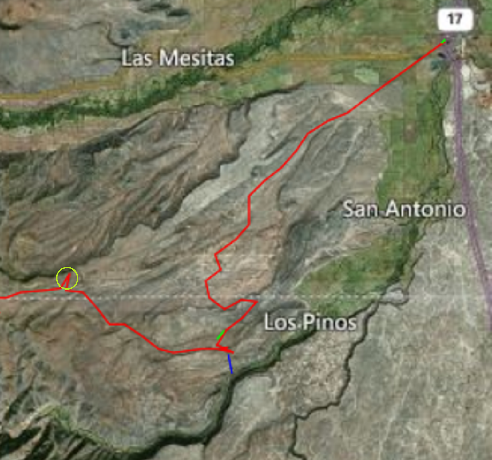
Leaving Antonito for Chama the train has a run of just over 5 miles on a slight grade to a point just beyond Fergueson Trestle (Upper red mark on picture).  A "ridge" running to the southwest is prominent to the west as we leave the Depot.  At Ferguseon trestle the track turns southward to parallel the ridge and commences a climb up Gravity Hill.
Plateau west of Antonito

The First Step - Gravity Hill
The ridge is actually a narrow plateau with a cap of volcanic breccia - Whiplash Curves are marked with the red circle.  The toe of this plateau is 400' above the plane on which the railroad runs at Ferguseon Trestle.  It is eight miles long and runs to the southwest.  Appearing dead level it actually inclines upward 500' from the toe near Ferguseon Trestle to the southwest at which point it is 900' above the cold desert at Ferguseon Trestle.

The climb up Gravity hill is a consistent 1.42% until reaching Lava Tank (Picture 1 - Lower Red Mark).  This run is the first of three long steps each of which runs from relatively level land to an abrupt climb.  The first step, up Gravity Hill brings us to a broad mesa which falls off to the Rio De Los Pinos 400' below on the south.  At the lower end of the Lava Tank Loop the rails have climbed to 8,479' over 500'  above Antonito the majority of which, over 350', was the 5 mile journey from Fergueson Trestle to Lava Tank.


The Second Step - Whiplash Curves
The second step commences as the train enters a life zone change and we see pine trees and Aspen.  as the train winds through uneven terrain; we cross numerous small fills which were first constructed as trestles to save money and expedite the construction.

We are in just inside Colorado here and slowly we approach an escarpment on which the railroad grade traces a pattern across the face, this is the "Whiplash Curves" (Picture 2).  At this point, the site of the long gone Big Horn Section House, the train begins a one and one-half mile climb from the base of the southern escarpment to the top of the plateau we originally viewed in Antonito.

Though the grade varies little from the previous 6 miles, we now traverse two complete reverse curves which tightly compresses the 110' climb into a limited amount of space.  Space is so limited the near 500' sweep of the 20 degree reverse curve on the top just brushes the edge of the northern escarpment. With this we surmount the plateau first seen to the west of Antonito; this second step took 7.5 miles from the lower loop of Lava Tank and a 400' climb.  The northern sweep of the curve is 8,872' over 1,000' above and 17 miles beyond Antonito with 34 miles and a 1,100' climb remaining to Cumbres and the "dreadful drop."

As we gaze at the Whiplash Curves from above our train journeys on, entering a land of complex geology and wondrous views.  We will soon see why this has been called "...The best example of narrow gauge steam operation in America...", in the National Historic Landmark award, and why the entire rail bed was awarded Landmark status by the American Society of Civil Engineers.  We will also see why, in 1885, Toltec Canyon was described as, "The King of Canyons".

The third step is very different but, that is another story...

The Third Step
*******************************************************

As I tell this ongoing story I admit that I am not a railroad civil engineer.  My grandfather and father were ran a structural steel fabricating and erection business in the Midwest and taking after my forefather's my son is a civil/environmental engineer.  I am retired from another profession but love history, railroads and things historic.  I have restored a home under DOI historic preservation guidelines and thus understand "the drill" when it comes to historic preservation.  This multi-part story is told based on my love of family, railroading and things historic.  It is told in language non-professionals hopefully understand, so if you an engineer or other professional of sorts, please excuse any goof-ups in my telling of this wonderful story.

Saturday, October 29, 2016

The Velvet Vault....

This time I have included a lot of the raw research and a few of many pictures sorted through to put one of these posts together. 

On our journeys between Antonito and Chama enter the region above Sublette, MP 306.06 and on to Osier MP 318.08 or the other way around if travelling from Chama to Antonito, we enter an area of intense geological activity.  The term "spectacular" was applied to this 12 mile section as early as 1885 with the writing of "Crest of The Continent" by Ernest Ingersoll.  He said thus:

"A narrow pathway carved out far up the mountain's side" - Lower Toltec Gorge
"Describing a number of large curves around constantly deepening depressions, we reached the breast of a mountain whence we obtained our first glimpse into Los Pinos Valley; and it came like a sudden revelation of beauty and grandeur.  The approach had been gentle and picturesque in character.  Now we found our train clinging to a narrow pathway carved out far up the mountain's side, while great masses of volcanic conglomerate towered overhead, and the face of the opposing heights broke off in bristling crags.  The river sank deeper and deeper into the narrowing vale, and the space between us to the banks was excitingly precipitous..."

As the years went on the description of the passage became less lyrical and more, shall we say, antiseptic.  A public accustomed to easy access to previously inaccessible areas was given a dry description of a once special place in a publication issued through the New Mexico Bureau of Mines and Mineral Resources which reduced Ingersoll's early description to this:

Mile Post 312.30 - "Phantom Curve, Reenter Colorado.  The cuts ahead afford a close view of chaotic breccias in the Conejos Formation and the many pedestal rocks left by erosion of alternating soft and hard breccias, flows and conglomerates."
James: "Scenic Trips to the Geological Past" May, 1972

A few years later a slightly more jaded readership was re-introduced to a by then overworked work, "spectacular", in order to impart a sense that this place was in some way special:

"Mile Post 313
This is one of the most spectacular sections of track along the C&TS route and has been photographed from nearly every conceivable angle.  The chaotic breccias and conglomerates that form the weird shapes, pedestal rocks and jumbled outcrops are the result of alteration by hot waters and weathering of the hard and soft breccias.  The wide variety of colors are due to chemical changes in the rocks.  A deep cut near milepost 312 is a good place to see these Conejos breccias.
Osterwald: "Ticket to Toltec"1976 

With very little effort the whole experience can be reduced to a human size thus:  Our Roman ancestors are celebrated for a remarkable feat of human hubris which is called their "greatest" contribution to construction. Using particularly difficult formula, for them, consisting of sand, volcanic ash and small stones they managed to stumble upon, and take credit for, one of natures multitude of original construction materials:


Conglomerates:
"Conglomerate (pronunciation: /kəŋˈɡlɒmərt/) is a coarse-grained clastic sedimentary rock that is composed of a substantial fraction of rounded to subangular gravel-size clasts, e.g., granules, pebbles, cobbles, and boulders, larger than 2 mm (0.079 in) in diameter. Conglomerates form by the consolidation and lithification of gravel. Conglomerates typically contain finer grained sediment, e.g., either sand, silt, clay, or combination of them, called matrix by geologists, filling their interstices and are often cemented by calcium carbonate, iron oxide, silica, , or hardened clay."
Wikipedia

Concrete:
"Concrete is a composite material composed of coarse aggregate bonded together with a fluid cement which hardens over time."
Wikipedia

Rome:
"The Romans used concrete extensively from 300 BC to 476 AD, a span of more than seven hundred years. During the Roman Empire.  Roman concrete... was made from quicklime, possolana, and an aggregate of pumice. Its widespread use in many Roman structures, a key event in the history of architecture termed the Roman Architectural Revolution, freed Roman construction from the restrictions of stone and brick material and allowed for revolutionary new designs in terms of both structural complexity and dimension.

Concrete, as the Romans knew it, was a new and revolutionary material. Laid in the shape of arches, vaults and domes it quickly hardened into a rigid mass, free from many of the internal thrusts and strains that troubled the builders of similar structures in stone or brick."

"Pozzolana, also known as pozzolanic ash...), is a siliceous or siliceous and aluminous material which reacts with calcium hydroxide in the presence of water at room temperature (cf. possolanic reaction). In this reaction insoluble calcium silicate hydrate and calcium aluminate hydrate compounds are formed possessing cementitious properties. The designation pozzolana is derived from one of the primary deposits of volcanis ash used by the Romans in Italy, at Possouli.  Nowadays the definition of pozzolana encompasses any volcanic material (pumice or volcanic ash), predominantly composed of fine volcanic glass, that is used as a possolan."
Wikipedia


Thus the remarkable geologic events covering millions of years have been reduced to this:  Sand, Lime and Small rock (aggregate).  Mix them together with a little water dump the slurry into a mold wait a bit and the Romans gave us this:

What clever creatures we are, over the years we did this:

And this:
Perhaps this:
Smaller:
BIGGER:
Meanwhile nature did her work and here is the result:
Phantom Curve - Conglomerate of Conejos Formation Breccias
And this:
Toltec Tunnel - 366' Metamorphic Rock


Turn her loose and this is what you get:

Massif:

Blanca Massive from Little Bear
Overwhelming:
Sangre De Christo - "The Blood of Christ"
 Sublime:
San Antonio Mountain at Twilight
 Vast:

Rio Grande Del Norte National Monument - Taos County, NM
 I think all youngsters have a moment when they realize how insignificant they are.  It may be on a beach pondering the uncountable grains of sand, sleeping with a window open listening to the sounds of a forest or laying on the ground at night looking into the velvet vault of the sky and realizing just how tiny we are.  In times such as this we need to ground ourselves and look at the world around us.  I do this by riding a train and telling a story about the land, the people and the railroad.  We look back and ask, "How could they do this with pick and shovel", now we need to look forward learning the lessons of our past.  If our kind could do all that with so little how much more are we capable of if we remember our place in the world nature has given us and treat it gently.

P.S.:  I started this post just after five this evening and posted it at nine thirty this evening.  I enjoy writing them I hope you enjoy reading same.

Thanks

j