 |
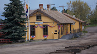
| You didn't really think it would be other than a railroad? |
It was particularly weird day with a fair amount of upset
over a botched mechanical job on Nate’s truck and the unseemly reaction of the
mechanic when asked to make it right. A bit
of conversation at home and some calm consideration was called for. It didn’t rectify the actions of the mechanic
but it did bring peace to Nate. With
that Nate, went on to a meeting while G and I decided to drive to Kampsville
for an iced cream.
The trip is around 12 miles from our home on Blue Ridge to
Kampsville with Michael about half way.
The drive is on a good two-lane highway and we set the cruise control at
55 mph to have a leisurely drive. It
took about 20 minutes due to the slow speeds down Rocky Hill and through
town. The iced cream was good and I got
a headache and chocolate dribbles all over my trousers. Just like a little kid.
On the way back I realized the distance between our home and
Kampsville is about the length of a section on the Cumbres and Toltec.
In the late 19th century the Denver and Rio
Grande divided a given section of track,
such as the journey from Antonito to Chama, into sections for
maintenance purposes. Each Section house
was responsible for the repair and maintenance of a four to five mile
section. This was the distance a track
crew could walk or travel by hand car to properly repair track work. Using this formula the 13 mile distance
between Chama and Cumbres was two full sections consisting of:
Chama to Cresco 7 miles – Cresco to Cumbres 6 miles.
The Cresco Section House was responsible for only six miles
of track because of the heavy 4% grade.
The bottom 4 miles were one-half of the Chama Section with
the remaining 4 miles running west on the now removed railbed to Dulce, New
Mexico.
The Cumbres Section House was responsible for three miles of
track down the helper grade toward Cresco on the west and four miles down the
tanglefoot curves toward Los Pinos Section house on the east.
And so on to the east through Los Pinos, Osier, Toltec,
Sublette, Big Horn and on into Antonito.
In 1938 essentially every other section house was removed as
the track maintenance work was mechanized.
There are now only four Section Houses still remaining all of which are
National Historic Sites and the 64 miles of railroad now neatly divide westbound
out of Antonito into 5 relatively even sections:
 | ||
| Top of Whiplash Curve |
15 Miles - Antonito to Whiplash Curves (Former site of Big
Horn Section House), a Telegraphone Booth remains at the location of the
Section house which was removed in 1968
11 Miles – Whiplash Curve (Former site of Big Horn Section
House) to Sublette Section House (A National
Historic Site)
 |
| Westbound #4 at Sublette, NM |
12 Miles – Sublette Section House to Osier Section House
(The second National Historic Site). There are many other structures and an explosives bunker not included in this picture Notice the color, that is another story.
 |
| Osier, Colorado |
 |
| Cumbres Section House being Restored |
 |
| Chama Depot |
Well then, you didn’t know we have a railroad between Hardin and Kampsville.
However, consider this have you noticed the relatively even
spacing of existing and former towns in the County? Were you also aware that the typical survey township
is 6 miles square with 36 sections one of which was as a “School Section”? Makes you wonder exactly why these township dimensions
were originally decided upon way back in the 19th century and the
answer to that is lost in the mists of time. I don't have a clue and it is not another story I will ever
research.
Some things are simply
meant to be a mystery such as why artists think black is a color and, did the big bang make a noise and why lint collects in ones navel.
